
Information on land cover is helpful with many questions relating to forestry and nature conservation. It is particularly relevant when modelling habitats or determining the suitability of habitats for many wild animals (e.g. capercaillie and chamois). These maps also provide valuable services in the modelling of forest habitat types or the creation of search areas for harmful organisms on forest trees. Previous land cover classifications such as the Corine land cover map (EEA 2018), or deciduous forest-coniferous forest or tree species maps derived from Sentinel-2 satellite data, are not suitable for some requirements. The reasons for this may be the coarse spatial resolution of the source data, misclassifications, or deviating class definitions. The previously available deciduous-coniferous maps (Straub et Reinosch 2023) could not adequately represent the deciduous-coniferous distribution, especially in sparse subalpine coniferous forests. The reason for this is the low spatial resolution of the Sentinel-2 data of 10-20 m and the associated mixing of the spectral reflection of ground vegetation and trees standing above it. For the modelling of forest habitat types, however, the proportion of deciduous and coniferous trees plays an important role.
A new land cover classification was therefore developed, using current orthophotos, new surface models, and a robust machine learning method. Six classes were modelled: deciduous trees, coniferous trees, mountain pine, meadow, rock and water. The classes “mountain pine”, “meadow” and “rock” provide additional important information on the occurrence of certain forest habitat types. Mountain pine are for example often admixed in larch-stone pine forests, and orchid-beech forests are often interspersed with grass vegetation or rocks visible “from above”.
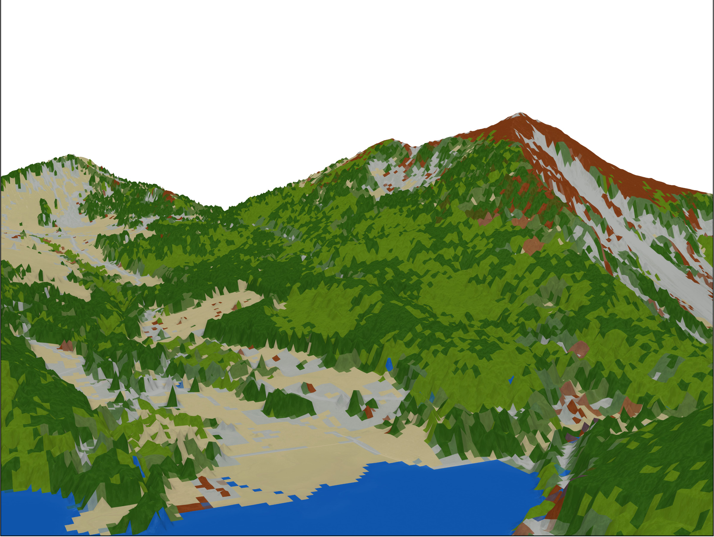
Fig. 1: 3-D representation of the land cover at the Spitzingsee lake- “View” from the Taubenstein cable car on to the Brecherspitz mountain.
Development of a model
The new land cover map was based on the digital orthophotos (DOP) and the digital aerial image-based surface model (iDSM) from the year 2022, as well as a current digital terrain model (DTM) from the Bavarian surveying administration with a spatial resolution of 20 cm (DOP) or 1 m (DSM and DTM; LDBV 2024 [Bavarian Agency for Digitisation, High-Speed Internet and Surveying]). The normalised digital surface model, also known as the “crown height model”, was derived from this input data. Common vegetation indices (NDVI, NGRDI, CVI) were calculated from Sentinel-2 data. All data were averaged to a spatial resolution of 10 m, and the variances of the variables within the 10 m were also calculated. In addition, known texture measures according to Hall-Bayer (2005) and the terrain ruggedness (TRI) were calculated. Accordingly, not only individual pixel values were considered as input data for the classification, but also their variances within the 10 m pixel and in relation to the neighbouring pixels.
The orthophotos from the official aerial survey are recorded at different times of the day and year during the vegetation period in so-called “flight batches”. This often carries the risk that both the light conditions - and with them the spectral reflection properties - and the phenological development of the trees may differ between the different flight times. For this reason, we trained a separate model for almost every flight batch and one for the entire Bavarian Alpine region. In order to address the different representations of the same class at the different flight times in the Alpine-wide model, this model was given an additional variable for each flight batch to advise it: “Caution: there is something different here!”.
To train the models, we set training points manually on the orthophoto. In the course of the development of the model, the number of training data was repeatedly increased to improve the accuracy of the modelled classes. At the end of this process, between 1,700 and 7,600 training points per class were available for the Alpine-wide model, and between 21 and 1,500 training points for the models of the individual flight batches.
Finally, we inspected the different models visually and combined the best models, in some cases also individual classes, into a land cover classification for the Alps.
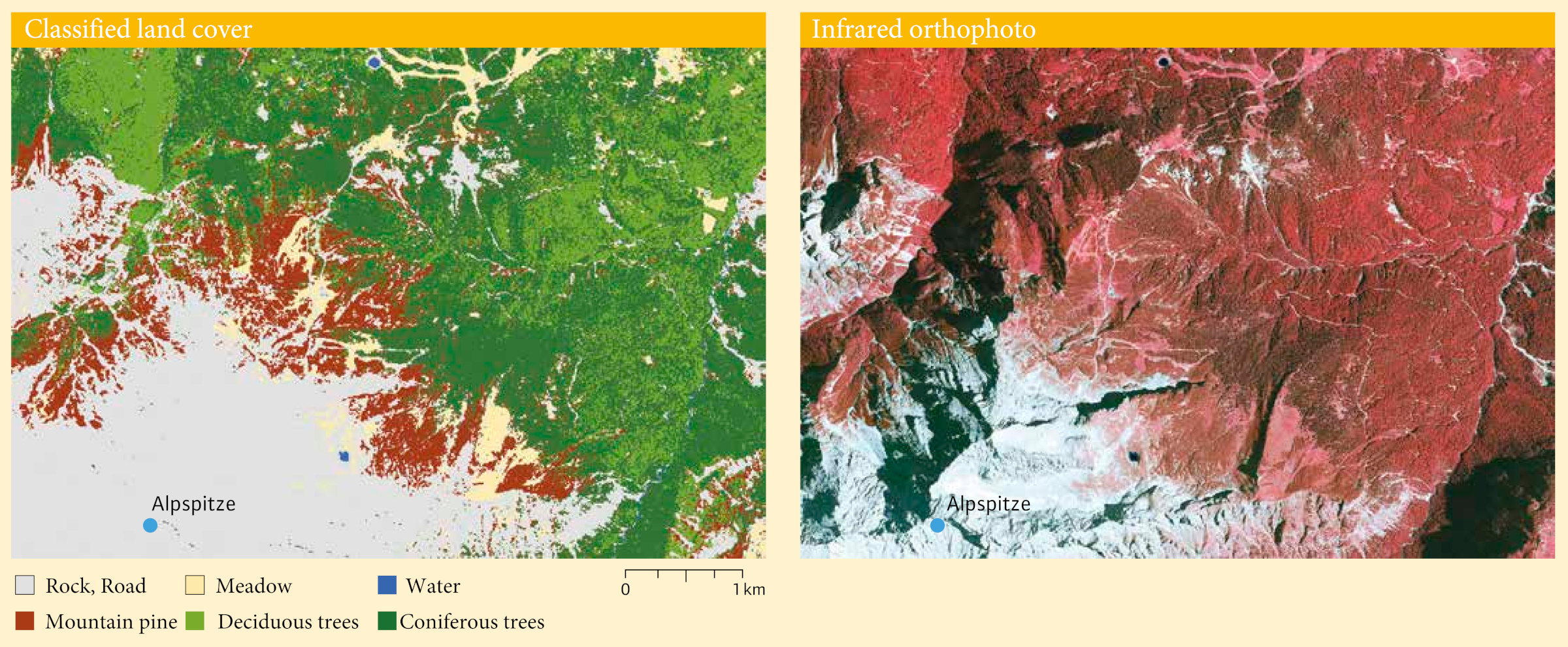
Fig. 2: Classified land cover south of Garmisch-Partenkirchen on the Alpspitze mountain (left); next to it a false-colour infrared orthophoto of the same section. The peak of the Alpspitze is surrounded by rocks, followed by meadows and areas of mountain pine. Finally, the land cover transitions to coniferous and deciduous forests.
Results
The model accuracies for all models are above 90 %, whereby the local models perform better than the Alpine-wide model. The individual classes can also be modelled well, with accuracies of over 89 % generally being achieved. During the final visual inspection on the stereo aerial image, individual misclassifications of mountain pine and green alder (Alnus alnobetula) nevertheless stand out. In some cases, the proportion of deciduous trees was over- or underestimated in very overexposed and shaded areas. In the Berchtesgaden area, there were also misclassifications of the mountain pine on treeless meadows.
Despite these errors, the new land cover classification represents a significant improvement in the data. They are also comparable to our previous small-scale tree group classifications using orthophotos, although we have now calculated a much larger area, and the initial data was thus much more heterogeneous. The integration of the spatial variances of the variable values, which complement the individual “raw values” of the variables, is likely to be the decisive factor for the good results.
Use of the land cover map
Due to its accurate prediction of deciduous and coniferous forests, mountain pine, meadows, and rock or scree areas, the map is now used for more than just modelling forest habitat types. The new map is for example being used to create a search area background map for the fungal disease Lecanosticta acicola on mountain pine (Pinus mugo spec.), or to optimise the forest area base layer in the project area. In future, this land cover classification is to be extended to include the foothills of the Alps. This is because there are several mountain pine and bog mountain pine bogs there that could so far only partially be recorded as forest areas using the semi-automated methods.
Summary
The new land cover classification of the Bavarian Alps not only records the proportions of deciduous and coniferous trees in sparse stands more accurately than previous classifications for the region, but also includes mountain pine (Pinus mugo), rocks and meadows as additional categories. The new classification was developed so that the forest habitat types protected under the Habitats Directive in the Alps could be modelled more precisely. However, it also provides a good basis for further habitat models and for analyses of forest composition.
The land cover map can be requested at geodaten@lwf.bayern.de .