
Given the wealth of lakes, rivers, streams and glaciers in Switzerland, water plays a major role in shaping the country’s natural landscapes. Alluvial zones represent a transitional area between land and water, where elements of wilderness and natural dynamics can still be observed. Floods and dry periods, erosion and sediment deposition give rise to constant transformations. Rivers may change their course or overflow, submerging dry areas, destroying existing habitats and creating new ones. These dynamic processes are responsible for the extraordinary diversity of species and habitats found in alluvial zones.
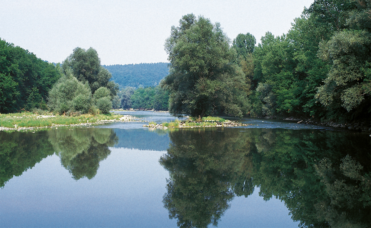
Fig. 1. Umiker Schachen near Brugg (AG). Photo: N. Kuhn
Throughout the centuries, man has sought to contain and modify watercourses in order to protect life and property against flooding and to reclaim land for agriculture. Today, the few natural watercourses remaining in Switzerland no longer pose a major risk.
Rather, they themselves now deserve protection, in view of the important role they play in the water cycle, their biological richness and their beauty. Four major European rivers – the Rhône, Rhine, Inn and Ticino – rise in the Swiss Alps, and their upper and middle reaches flow through this country. The Swiss Alps are also home to some of Europe’s most important glaciated areas. This means that Switzerland has a special responsibility to participate in efforts to conserve Europe’s alluvial zones.

Fig. 2. Sensegraben (BE/FR). Photo: M. Roggo
An ecosystem shaped by water
Alluvial zones can be roughly divided into three areas.
- As the profile of the river bed is frequently modified by water and sediment, only pioneer plants can flourish here, developing rapidly between periods of flood and establishing themselves anew each year. Willow shrubs may also take root in the coarse gravelly soils.
- Alluvial terraces adjoining the river bed are dominated by willow and alder. Conditions here are sufficiently stable (between periods of flooding) to permit the development of pioneer forests, known as softwood forests.
- Terraces lying further away from the watercourse and higher up are rarely flooded, but they are still (permanently or periodically) influenced by groundwater. If vegetation grows undisturbed for several years or decades, a hardwood forest will develop, comprising species such as ash, maple and elm, or even beech, oak and spruce.
At altitudes of up to 700 m above sea level (asl), hardwood forests are the most important alluvial plant community in terms of extent. From 1000 m asl, however, they disappear entirely, and softwood is the only type of alluvial forest belt. From around 1600 m asl, softwood species are no longer found either, as the forest gives way to shrubs. Finally, in glacier forelands and alpine alluvial plains above the tree line, pioneer plants are the dominant type of vegetation.
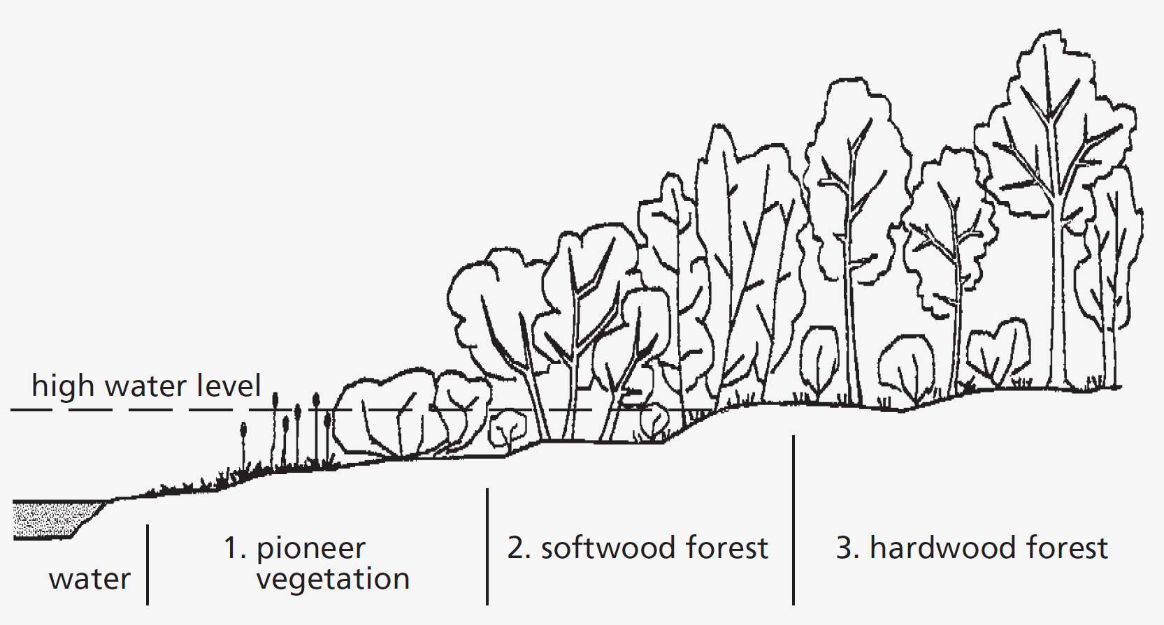
Fig. 3. The three areas of alluvial zones.
Exceptional diversity
Within a small area, there is a wide variation in factors such as age (the period that has elapsed since a specific site was formed or regenerated by flooding), humidity, and structure and nutrient content of the soil. Alluvial zones thus represent complex mosaics of highly diverse habitats.
To date, almost 1200 plant species have been recorded in Switzerland’s alluvial zones, although the actual total is probably in excess of 1500 species. This would mean that 0.55 % of the area of the country accounts for half of the total variety of Swiss flora. There is also a great diversity of wildlife: the various alluvial habitats support butterflies, dragonflies and grasshoppers at different stages of their life cycles and provide food and refuge for amphibians, fish and numerous species of birds and mammals.
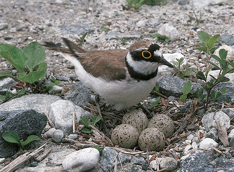
Fig. 4. Nest of the little ringed plover (Charadrius dubius). Photo: P. Keusch
Ecosystems under threat
As a result of watercourse modifications, the draining of floodplains and (more recently) transport infrastructure developments, urban sprawl and tourism, nearly 90% of Switzerland’s alluvial zones have disappeared. Similar trends have been observed in neighbouring countries. Low residual flow rates (due to hydropower facilities) in most alpine watercourses, the damming of rivers and the deepening of river beds have gradually transformed alluvial vegetation, with the development of drier, less typical plant communities.
Eutrophication of habitats (due to excessive nutrient inputs) has also contributed to the loss of diversity of alluvial vegetation. Biological exchanges along rivers and streams and between watercourses, banks and surrounding areas are impeded by barriers such as dams, weirs, transport infrastructure and intensively cultivated land. Local activities such as landfills, earthworks, drainage, gravel extraction, etc. may also be factors leading to the degradation of alluvial habitats.
At present, two thirds of Switzerland’s lowland alluvial zones of national importance are no longer characterized by natural dynamics: flooding is prevented by dams or modified discharge regimes. Only a third can still be described as active alluvial zones, i.e. with erosion and sediment deposition still occurring and a discharge regime that permits periodic flooding. However, despite the lack of natural dynamics, even stabilized alluvial zones still represent valuable habitats. On the Central Plateau, where all the major rivers have been modified, the alluvial character of many forests may be preserved for long periods thanks to shallow water tables accessible to tree roots.
In the case of the alpine alluvial plains listed in the Federal Inventory, the situation is different: only 5 of a total of 66 sites have an altered discharge regime (e.g. because they lie below a reservoir).
Revitalization
In stabilized alluvial zones where erosion and sedimentation processes are at least partly reactivated and a discharge regime giving rise to periodic flooding is permitted, the biotic communities typical of alluvial zones may be regenerated. The habitat is thus revitalized. Of course, this is not always possible. Unrestricted natural dynamics cannot be permitted in areas where human life and property are threatened. Nonetheless, revitalization remains an option for numerous stretches of watercourses.
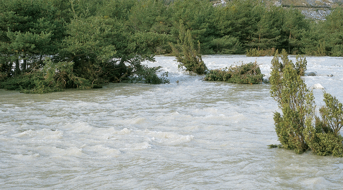
Fig. 5. The Rhône in spate at Finges (VS). Photo: Alluvial Zones Advice Centre
The main measures employed for the revitalization of alluvial zones are as follows:
- definition of boundaries within which a river is allowed to flow freely
- relocation of dams to permit more extensive flooding
- increasing average residual flow rates and flood discharge
- in exceptional cases, lowering the alluvial zone profile to create new areas for flooding
In cases where genuine revitalization is impossible for safety reasons, biological diversity can be preserved or even enhanced by creating alternative habitats. The following measures may be appropriate:
- reopening old side channels
- restoring or excavating oxbow lakes
- diverting tributaries to flood specific areas of land
- creating ponds
Alpine alluvial zones
There are two types of alpine alluvial zones: glacier forelands and alpine alluvial plains. Habitats of both types are characterized by dynamic processes, with the landscape being constantly transformed. Like lowland alluvial zones, they comprise waterbodies and adjoining areas with the typical zonation. On account of the altitude, pioneer vegetation is dominant, while forests are relatively rare.
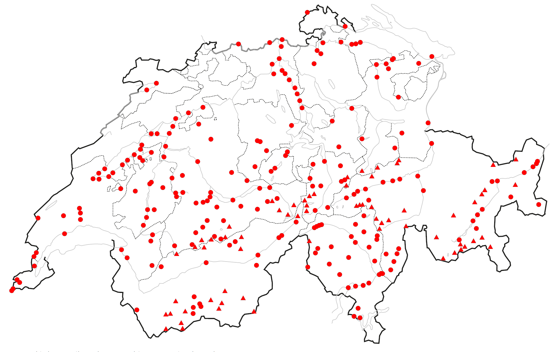
Fig. 6. Geographical distribution of alluvial zones of national importance.
Glacier forelands are surfaces that have been exposed by the retreat of glaciers since the Little Ice Age (around 1850). Two different types of area are to be distinguished. Along glacial streams a characteristic transition from water to land (zonation) can be observed, shaped by the alternation of flooding, erosion and sediment deposition. Outside the zones subject to the influence of streams, a different pattern of vegetation is found in the areas now free of ice. The receding glaciers have left behind a rich variety of landforms and soil types of different ages. From the tongue of the glacier to the areas that have been uncovered since 1850 a typical succession is detectable, with the various stages juxtaposed. In glacier forelands, a highly diverse mosaic of plant communities can be found within a very restricted area.
Alpine alluvial plains are found in relatively broad, flat uplands of alpine valleys. They exhibit the same zonation as the lower-lying alluvial zones. In contrast to the glacier forelands formed relatively recently, many alpine alluvial zones have been used by mountain farmers for generations. Unlike those in lowland areas, alpine alluvial zones are still largely intact. The aim should be to ensure that they can continue to develop unimpeded and that they are protected from any factors that may lead to their degradation.

Fig. 7. Alpine alluvial zone: Plaun Segnas Sut (GR). Photo: Alluvial Zones Advice Centre
Compensation for alluvial zone protection
Under the relevant laws and ordinances, landowners and - managers who accept a reduction in income in the interests of conservation are entitled to receive financial compensation. Payments are also made for various types of ecological performance that do not generate profits. Compensation is paid for upkeep measures required or losses incurred annually. But aid is also payable for one-off contributions, such as revitalization measures or the development of a protection and management plan. Financial aid may also be paid from agriculture, forestry or watercourse engineering budgets. The allocation of subsidies is coordinated by the cantonal nature protection agencies.