



Climate change, storms, heavy rainfall and bark beetles are threatening our mountain forests. For the particularly climate-sensitive Tangelhumus sites in the Alpine region, there is currently little information available on the impact of these threats. The fundamental question is how the thickness of the Tangelhumus layers in the Bavarian Alpine region is changing as a result of climate change and whether humus depletion is occurring. On limestone and dolomite sites in particular, humus layers are often the most important - and sometimes the only - nutrient and water reservoirs. The cool and moist conditions in the Bavarian Alpine region have a stabilising effect on these humus layers. But what will happen to these organic soils if temperatures continue to rise as a result of climate change, which is having a particularly severe effect on the Alpine region?
Selection of sites and installation of the humus level gauges
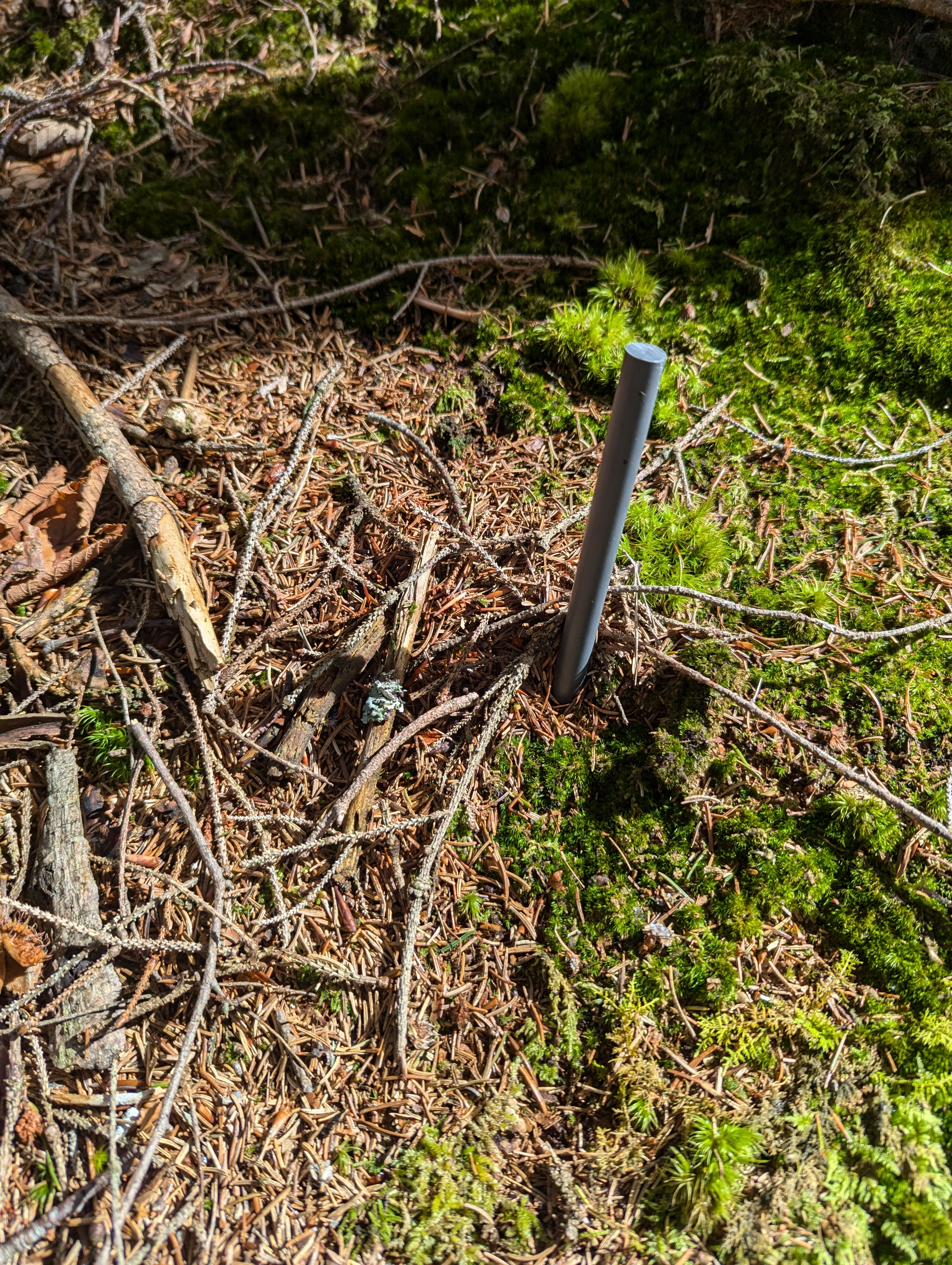
Fig. 1: Example of a humus level gauge. Photo: Roman Laniewski
In order to answer the question posed above, a total of 405 level gauges in the form of PVC rods were installed on 27 sites in the state-owned forest in the Bavarian Limestone Alps in 2020 and 2021 to monitor changes in the thickness of the Tangelhumus layer (Figure 1). This facilitates long-term documentation of humus development. The criteria for the selection of the sites included the east-west gradient, the altitude, the exposure, and the stand type (mixed mountain forest, pure spruce stand, calamity area).
Within each site, 3 small areas approximately 3 to 10 metres apart were selected. For each small area, 5 PVC rods were sunk as deep as possible into the ground and cut off 10 cm above the surface of the terrain. Starting from a central rod, a further rod was installed at a distance of 80 cm in each cardinal direction. During the repeat survey in 2024, i.e. 3 or 4 years after their installation, the height of the installed PVC rods above the surface of the terrain was recorded again in order to detect any changes in the thickness of the humus layer. All analyses presented here refer to the year, as the rods were installed in 2020 and 2021 and therefore only the annual basis makes sense for a joint evaluation of all data.
Change in humus thickness in the individual observation areas
Figure 2 shows the locations of the humus level gauges and the occurrences of Tangelhumus in the individual observation areas as determined by the ALPENHUMUS project (Ewald et al. 2020). Humus level gauges were installed in all of the five designated Alpine regions with the exception of the Chiemgau Alps.

Fig. 2: Positions of the observation points with the respective Tangelhumus distribution in the Bavarian Alpine region (Ewald et al. 2020), as well as the annual change in the humus layer.
The Berchtesgaden Alps have the highest proportion of Tangelhumus at 19 %. At the same time, this is also where the greatest change in the humus can be observed, averaging – 0.3 cm per year. The Lattengebirge mountains, where the Berchtesgaden humus level gauges were installed, was severely affected by storm Kyrill. This storm caused the deforestation of large areas, thereby exposing the forest floor to increased solar radiation and thus higher temperatures. The increased irradiation led to increased humus degradation. Although the humus level gauges were installed not only in calamity areas but also in forest stands, these were sparse stands that had been damaged by the storm or were in the process of collapsing.
In the Mangfall mountains, the humus level gauges were installed in Langenau, an area characterised mainly by undisturbed deciduous or mixed mountain forest. The proportion of Tangelhumus in this area of the Alps is 7 %; the mean value of the change in humus in the observation area is – 0.05 cm per year.
With a proportion of 13 %, a relatively large amount of Tangelhumus is to be found in the Werdenfelser Land region. Over the last 3 years, an average annual change in humus of – 0.15 cm has been recorded there. The situation is similar in the Allgäu Alps, where an average annual humus loss of 0.11 cm was observed in the stands studied. The thickness of the humus is therefore decreasing in all the areas under consideration, but depends on the site.
Development of humus thickness across all observation areas
Overall, 138 gauges (40 % of the gauges still present in 2024) showed no major changes in humus thickness (0 ± 0.125 cm/a). An increase in humus thickness was observed at 49 gauges (15 %) and a decrease at 153 (45 %). The average change in humus across all gauges is – 0.14 cm per year. The maximum increase in humus is approximately + 0.75 cm per year, and the greatest loss of humus is around – 1.50 cm per year. Overall, this shows a clear trend towards a decrease in the thickness of the Tangelhumus in the Bavarian Limestone Alps.
Annual change in humus thickness according to stand type
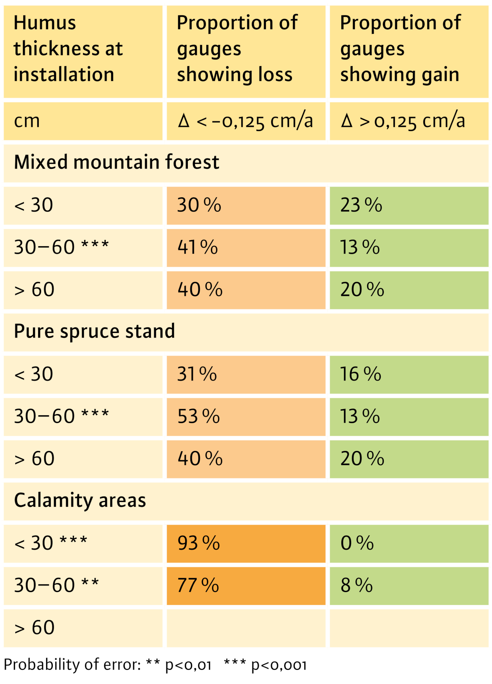
Fig. 3: Evaluation of the annual change in humus; classified according to the humus thicknesses determined when the gauges were installed, and the stand types found; statistical evaluation with the non-parametric Wilcoxon test: marked depth levels show a change in humus thickness that is significantly different from zero.
To evaluate the annual change in humus, the thicknesses measured during installation of the gauges were used. These were divided into three classes: < 30 cm, 30–60 cm and > 60 cm (Figure 3). In the case of the calamity areas, the values in the > 60 cm class were not shown, as there are only two gauges in this category. It is striking that for all three stand types in each humus thickness category, the proportion of gauges recording loss of humus clearly outweighs the proportion of those with gains in humus. In the 30-60 cm thickness category, the humus depletion is statistically significant for all 3 stand types (mixed mountain forest, pure spruce stand, calamity areas), and in open areas also in the < 30 cm thickness class. The situation is particularly critical on the calamity areas and here especially on the sites with a humus thickness < 30 cm, as these lose an average of 2.3 % of their thickness annually. In extreme cases, the annual humus loss on these sites is as high as 7 % at –1.00 cm. Similar observations were made in the Höllengebirge mountains (Upper Austria), where a humus loss of 0.9 cm/year was observed in the first three years after a windthrow with bark beetle infestation (Göttlein et al. 2014).
Difficulties and problems
Of the 405 humus gauges originally installed, 340 could still be measured in 2024, which corresponds to 84 %. One reason why gauges were missing is that some of them had been destroyed during logging or road construction measures.
Particularly on steeper slopes, the installed gauges act as a small obstacle that hinders the natural downward movement of freshly fallen litter. Part of the measured humus accumulation is due to this effect, so that the humus levels on such sites tend to convey a positive picture overall.
Recommended action
Tangelhumus sites are at risk, especially if they lose (part of ) their forest cover as a result of catastrophic events (storms, bark beetles) or during forest management measures. To optimise the preservation of the humus layer and thus the forest viability on these sites, the aim should be to create permanent forest structures which, due to their plenter-like structure, have as broad an age structure as possible. This minimises their susceptibility to disturbance. During the necessary thinning measures, as much biomass as possible should remain in the stand. Game population control is a prerequisite for the sustainable regeneration of the stands.
Summary
Rising temperatures lead to increased mineralisation and thus to a degradation of the Alpine Tangelhumus. Although the changes observed on average may appear small, the maximum values of humus loss in the mixed mountain forest, in spruce stands, and above all on the calamity areas are worrying. Particularly on sites that already have a low humus layer (< 30 cm), annual degradation rates between 2.7 and 7.1 % mean that within a relatively short period of time, the viability of these sites for forestry will be severely threatened. Humus protection must therefore be a top priority in the management of Tangelhumus sites. Forest canopies should therefore be kept closed as far as possible, and attention should at the same time be paid to sufficient and sustainable regeneration.